 |
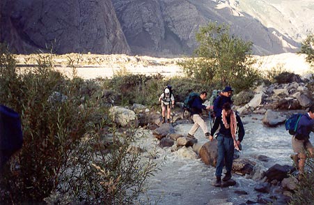
Early morning stream crossing |
The next morning started with a tricky stream crossing, but relatively tame. Then we started out on what seemed like a narrow path that kept climbing higher and higher over the river.
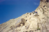
Finally we got to a point where the path seemed to just end and Rex had us wait until the porters all passed us. But going where...? Well, what the Lonely Planet Guide to Trekking in Pakistan describes as an "exposed path" was actually no more than a series of very narrow (a foot or less) ledges along the face of the cliff. We were over
400 feet above the river at this point, so if the fall didn't kill you, the boulders floating down the river would when you fell in. No ropes, nothing to hold onto except for the spaces between the rocks on the cliff face. At one point the ledge made a 90 degree turn around a corner, and you had to lift your foot into space and put it blindly around the corner to find the new ledge. Needless to say, for most of us this was not fun.
 |
Just in case you didn't think it was steep... |
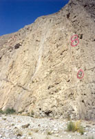 |
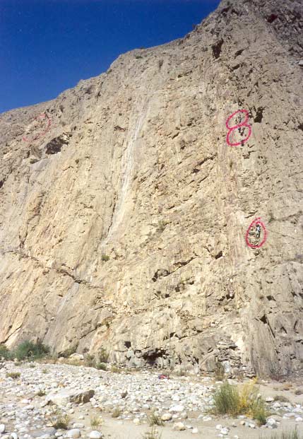
The Cliffs - yes, those dots are people |
Then, just when you thought it was impossible, it got worse. The last part of the exercise required climbing down what felt like a sheer cliff face. Luckily I had the help of Nabi for most of this. When I got to the bottom and looked up I realized that the reason it felt like a sheer cliff face was that it WAS a sheer cliff face, 450 feet high. This life-threatening scramble took over two hours. The worst part about this was that we would have to do it again on the way back!
No photos taken ON the cliff face for obvious reasons, but when we got to the bottom, after it was over, it made most of us a bit queasy to look back at where we had just been, and say a short prayer of thanks that we had all made it in one piece. Lots of photo opportunities, now that we were on terra firma. To give you some perspective, the circled dots in the photo on the right are people.(Thanks to the intrepid Bill Miller for these photos of the cliffs.)
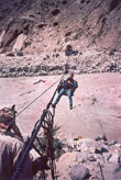 |
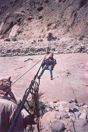
Mark sails across the river |
The "name" we gave to the cliffs -- the Cliffs of Jola -- was in no way an official name for them. They were dubbed this by our group because they were the route to the "Jola" -- the box hanging from the rope system by which we got across the river, 20 minutes upstream from the bottom of the cliffs. While this was a rather "interesting" way to cross the river, in fact it was quite safe and stable, and after scrambling along ten-inch ledges for hours, was actually relatively fun. We took turns climbing into a deep wooden box, called a Jola, and the "Jola Man" pulled it across the river with a series of pulleys from the other side. The Jola Man came from Askole every day to do this job. Sadly, I understand that the Jola has since been replaced with a bridge. Much more efficient (it takes ages to get everyone, including all the porters and gear, across the river this way), but not as picturesque.
We camped close to the other side of the Jola, arriving in time for lunch. A short but dramatic day from which we deserved the rest.
The March to Paiju
 |
The March to Bataan |
The first thing the next day we walked by the cliffs from the other side of the river. They still looked daunting. This day was a long hot slog through shadeless colorless country. The mountains were getting bigger, and you could see glimpses of snow-capped peaks, but it was a terrible chore to put one foot in front of the other for hours on end -- 12 hours to be exact. The sun was roasting hot and there was no respite. We referred to this day as the "March to Bataan," as we felt some comraderie with those unfortunate souls of WWII. But our goal was Paiju (pronounced "pa-yoo"), a sort of trekkers village where we would have a well-deserved rest day for altitude acclimatization.
 |
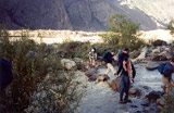
Crossing Paiju Stream |
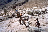
But before we could get there we had to cross what was euphemistically called "Paiju Stream." These streams coming down from the glacier gathered force over the course of the day due to the ice melting under the scorching sun. By the time we got to the "stream" it was a raging rapid, and the porters had to make a human chain across the river to get us each across. Plus, the water was absolutely freezing cold. Just five minutes in it and your feet were completely numb. In another half hour the water would have been impassable until the next day. When we came back this way the next week on our way back to Askole, we crossed the water early in the morning, at which time it really was a stream, and you just hopped across from rock to rock. What a difference a few hours in the sun makes!
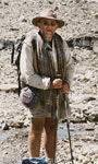 |
Rex |
The rest day at Paiju, where we saw the last (small) bits of green shrubbery on the trek, was well needed. We had a chance to do laundry, wash up in the river, teach two young porters (who couldn't have been more than 14) to play frisbee, and generally just laze around. The height of the afternoon was too hot to do anything but hide in the dining tent and read or sleep. Rex held court with several other trek leaders also camping in the area.
Arriving at Baltoro Glacier
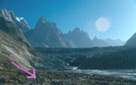 |
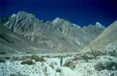
Beginning of Baltoro Glacier |
We left Paiju early in the morning setting off for the Baltoro Glacier, which we would be living on or along for the next eight days. You could see the mouth of the glacier from Paiju, and it took us about an hour and a half to arrive at it's beginning. The photo on the left is us approaching the glacier. To give you a sense of scale, the pink arrow is pointing to us (the tiny dots -- seen better if you look at the enlarged picture), and the dark mass settled in the valley is the glacier. At that point, the mouth of the glacier was a pile of rocks that were five or six stories tall. The glacier doesn't look like those nice shiny white things in picture books of the Alps -- here it's covered by a layer of rock and debris that masks a hunk of ice that is 40 km. long and 300 feet deep.
The scenery on the glacier is best described as other-worldly -- you felt as if you should be on some distant planet. Photos and descriptions on the pages that follow...